Matthias9L
Legacy Member
zarathustra zei:Spijtig genoeg wel
Achja, dan denkt u dat maar.
Volg de onderstaande video om te zien hoe je onze site als web-app op je startscherm installeert.
Opmerking: Deze functie is mogelijk niet beschikbaar in sommige browsers.
zarathustra zei:Spijtig genoeg wel
Matthias9L zei:Achja, dan denkt u dat maar.


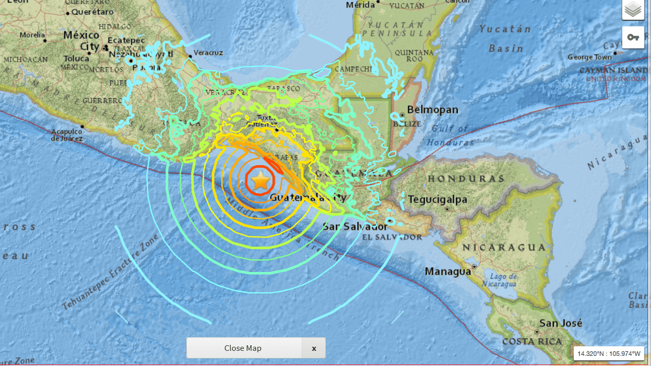
Mount Agung alert status raised to 3 (out of 4)
The National Disaster Mitigation Agency (BNPB) said the alert status of Mount Agung, the highest mountain in Bali, had been raised to siaga (alert level 3) following an increase in volcanic activity.
The BNPB released a written statement on Monday evening which stated that the Volcanology and Geological Disaster Mitigation Center (PVMBG) had called on the agency and the Bali Disaster Mitigation Agency (BPBD) to take preemptive measures in case of an eruption.
The PVMBG further called on people living in the areas surrounding the mountain and visitors to avoid any activity, including hiking and camping, near the crater of Mt. Agung, and all areas within a 6 kilometer radius of its peak.
“Those areas must be void of any activity,” said BNPB spokesman Sutopo Purwo Nugroho.
He asked local people and tourists in the volcano’s surrounding areas to remain calm but also warned them to stay alert.
Coordinating with the National Police and the Indonesian Military, the BNPB has conducted a series of activities to prepare people in case of an emergency.
“We have asked all people to prepare their clothes, food and valuable items in case they have to be evacuated suddenly because of an eruption," Sutopo said.
Mt. Agung’s volcanic activity has been increasing since earlier this month, indicated by a string of volcanic tremors. The volcano last erupted in 1963, during which a pyroclastic flow released from its crater damaged several villages nearby. At that time, the eruption caused around 1,100 deaths. (ebf)
Vulkaan op Bali staat op springen
Op Bali hebben de autoriteiten de alarmstatus rondom de vulkaan Agung verder verhoogd naar drie. Ook zijn de evacuatiegebieden rondom de actieve vulkaan verder uitgebreid.
De vulkaan Agung ligt op circa 70 kilometer afstand van Kuma op het vakantie-eiland Bali en is een zeer toeristische trekpleister. Het is de hoogste berg van Bali. De laatste keer dat de Agung uitbarstte was in 1963. Destijds kwamen meer dan 1100 mensen om het leven door pyroklastische stromen (wolken van hete lucht, gas en lava) die enkele dorpen overspoelden. Toeristen zijn gewaarschuwd dat ze op minstens zes kilometer afstand van de top moeten blijven en dat er een verboden zone van 7,5 kilometer is ingesteld ten noorden, zuidoosten en zuidwesten van de vulkaan.
De laatste weken is de vulkanische activiteit in en rond de vulkaan sterk toegenomen. Kleinere aardbevingen worden in het gebied gevoeld en kleine erupties van vijftig meter hoog zijn inmiddels ook al gezien. Inwoners binnen een gebied van twintig kilometer rondom de vulkaan is aangeraden om klaar te zijn voor eventuele versnelde evacuatie mocht de alarmstatus verder naar vier worden verhoogd.
Even the most simplistic hydrogen bomb would create an earthquake registering as a 7.0M, and according to the study, this would be enough to trigger an eruption. If it did, then what would happen? Well, let’s take a look at the aforementioned history of Paektu.
Although there was a minor eruption back in 1903, back in the year 946, a true cataclysm occurred. Known as the Millennium Eruption, it unleashed 100 cubic kilometres of volcanic debris, smothered the surrounding landscape in pyroclastic flows, and unleashed 1,000 times more energy than the famous 1980 eruption at Mount St. Helens.

De laatste uitbarsting van de Agung dateert uit 1963. Toen kwamen 1.100 mensen om het leven.
Mount Agung in Bali is experiencing unprecedented levels of seismic activity and could erupt in a “matter of hours” if tremors continue, Indonesia’s volcanology centre has said.
A VEI 5 eruption during 1963-64 produced pyroclastic flows and lahars that caused extensive damage and resulted in more than 1,100 deaths.
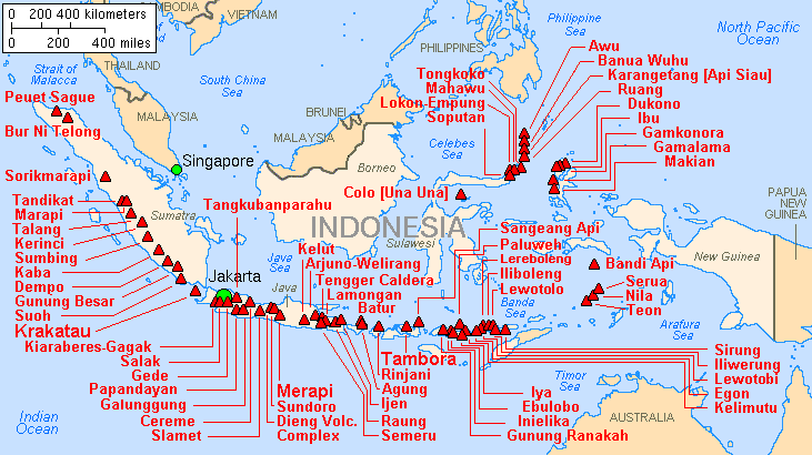
De Toba-catastrofetheorie stelt dat de evolutie van het menselijk ras in belangrijke mate is beïnvloed door een uitbarsting van de supervulkaan Toba op Sumatra in Indonesië, circa 74.000 jaar geleden. Over de dood en verderf zaaiende supereruptie zelf bestaat geen twijfel. Volgens Stanley H. Ambrose van de Universiteit van Illinois is het mogelijk dat het menselijk ras Homo sapiens toen is gedecimeerd tot slechts enkele duizenden individuen, die, in de barre vulkanische winter die volgde, noodgedwongen beter leerden samenwerken, en zo een evolutionaire sprong maakten die hen in staat stelde om korte metten te maken met de Homo erectus en de neanderthaler, die van nature beter bestand waren tegen de kou, en dus in grotere aantallen de eruptie en de winter hadden overleefd.
Dit evolutionaire 'oog van de naald' zou het gebrek aan genetische diversiteit verklaren, die uniek aan Homo Sapiens is. De theorie kent overtuigde aanhangers, maar er zijn ook lieden die haar sterk bestrijden. De genetische "bottleneck" (flessenhals) zou bijvoorbeeld zeker 100.000 jaar voor de Toba-uitbarsting veroorzaakt zijn.


Records from ship logs have determined both 1815 and 1816 were active hurricane seasons, with at least 12 tropical cyclones ascribed to 1816 alone. This is some evidence that a northward-displaced Intertropical Convergence Zone appears to be partially responsible for the increased tropical cyclone activity in 1816, which was the famed Year Without a Summer.[20]
1) June 5–8: A hurricane brushed the Florida Keys, causing the loss of 5 ships.[5] Interestingly, it appears to have been lured northward by an unusual June snowstorm across New England.[21]
2) Haiti, around Port-au-Prince, was struck by a hurricane on August 18.[22]
3) Martinique, eastern Cuba, and South Carolina were lashed by a hurricane between September 3 and September 11.[1]
4) A tropical storm affected Virginia on September 18 before moving northeast into New York. The tropical storm caused heavy flooding in the James River area.
5) Hurricane San José de Cupertino of 1816 There is record of a hurricane moving by Dominica[1] and Barbados[23] on September 15 before devastating Puerto Rico on September 18. [1]. The hurricane then hit eastern North Carolina on September 23 wrecking nine vessels at Ocracoke Bar. [24]
6) On October 16–17, a severe gale was experienced in Dominica and Martinique. During the storm, an earthquake shook the region.[23]